
The Great Barrier Reef lies off the coast of Queensland, Australia, stretching about 2,300 km from the tip of Cape York in the north to near Bundaberg in the south. It’s made up of around 2,900 individual reefs and 900 islands, and the easiest way to visit is a day tour from Cairns or Port Douglas.
The Great Barrier Reef at a glance
| Feature | Detail |
|---|---|
| Location | Off the Queensland coast, north-eastern Australia (Coral Sea) |
| Length | About 2,300 km |
| Area | About 344,400 km² |
| Individual reefs | Around 2,900 |
| Islands & cays | Around 900 |
| Distance offshore | From ~15 km in the north to 150 km+ in the south |
| World Heritage listed | 1981 |
| Main gateway towns | Cairns, Port Douglas, Airlie Beach (Whitsundays), Townsville, Bundaberg |
Where is the Great Barrier Reef?
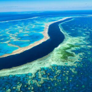
The Great Barrier Reef runs the length of the Queensland coast in north-eastern Australia, in the Coral Sea. It begins near the tip of Cape York in the far north and reaches south to around Bundaberg and Lady Elliot Island — roughly 2,300 km, making it the world’s largest coral reef system and the largest living structure on Earth, visible even from space.
It isn’t a single wall of coral. It’s a vast network of around 2,900 separate reefs, coral cays and continental islands, sitting anywhere from about 15 km off the coast in the north to more than 150 km offshore in the south. That’s why “the reef” looks different depending on where you visit — and why the gateway town you choose matters. Read more in our guide to where the Great Barrier Reef begins and ends.
A picture of the map (for anyone who can’t see the image above): imagine the Queensland coastline running roughly north–south. The reef sits offshore along almost its entire tropical length, like a broken ribbon parallel to the coast — widest and furthest out in the south, narrowing and drawing closer to shore in the far north. The main visitor gateways sit along the coast from Bundaberg in the south, up through the Whitsundays and Townsville, to Cairns and Port Douglas in the tropical north.
The regions of the reef (and where to access each)
Far Northern Reef (Cape York)
The most remote and pristine section, reached mainly by multi-day expedition liveaboards rather than day tours. Wild, rarely visited, and spectacular.
Cairns & Tropical North
The most popular and accessible part of the reef, and the main visitor gateway. From Cairns, day boats reach outer-reef sites such as Norman, Saxon and Hastings Reefs and Michaelmas Cay in around 90 minutes. The easiest place to see the reef in a single day.
Port Douglas
An hour north of Cairns, gateway to the pristine Agincourt Ribbon Reefs on the outer edge of the continental shelf — a favourite for clear water and vivid coral.
Townsville
Gateway to the central reef and the famous SS Yongala wreck dive, plus Magnetic Island. Quieter than Cairns, with excellent diving.
The Whitsundays
Seventy-four islands where the reef meets white-silica beaches like Whitehaven. Base yourself in Airlie Beach for sailing, island-hopping and reef day trips, including Heart Reef from the air.
Southern Great Barrier Reef
From Bundaberg and the town of 1770, reach the Capricorn-Bunker group and Lady Elliot and Lady Musgrave Islands — renowned for turtles, manta rays and snorkelling straight off the beach.
How far is the reef from the coast?
It varies a lot. In the far north the outer reef can be as little as ~15 km offshore; off Cairns and Port Douglas the popular outer-reef sites are roughly 40–70 km out (about 90 minutes by fast catamaran); and in the south the reef swings much further out — over 150 km in places. The inner reef and fringing reefs around islands are closer to shore and calmer, which is why island-based reef experiences suit families and first-timers.
The easiest way to see the Great Barrier Reef
For most visitors, the simplest and best-value way to experience the reef is a day tour from Cairns out to the outer reef. Reef Experience visits two outer-reef sites with snorkelling, a free scuba dive and lunch included — a complete reef day without a multi-day trip.
See it for yourself: Now you know where the reef is, the easiest way to experience it is a day tour from Cairns. Reef Experience visits two outer-reef sites, with a free scuba dive, guided snorkels and lunch included, from $280.
Official reef zoning maps (for boating, fishing and diving)
If you’re heading out on your own boat, the Reef Authority (GBRMPA) publishes official zoning maps that show what you can do where. The reef is a protected marine park, and colours on the zoning map tell you which activities are allowed in each area.
“The Great Barrier Reef is immense. Understanding its zones and structure helps you get the most from your visit — and helps the reef too.”
Great Barrier Reef Maps – Zoning, Moorings, and Marine Park Boundaries
Great Barrier Reef Maps Quick facts (skim first)
- Official Great Barrier Reef maps show zone colours: Green = no-take, Yellow = limited take,
- Blue = general/habitat, Pink = preservation.
- You can download maps, use an interactive map viewer, or the Eye on the Reef app (works offline).
- Public moorings protect coral use them first; avoid no-anchoring areas.
- Some sites have Special Management Areas or local Plans of Management (extra rules).
- Printed/app maps are guides; legal boundaries are defined in the Zoning Plan (coordinate-based).
- If unsure, choose the most protective option and ask your skipper.
About Great Barrier Reef Maps
Planning your reef day? Here’s a simple guide to Great Barrier Reef maps—where to get the official zoning maps, how to read the colours, and how to find public moorings and no-anchoring areas. We also show interactive map options and an offline app for when you’re out of range.
Download official Great Barrier Reef maps
- Zoning maps
- Interactive map viewer / Geohub:
- Eye on the Reef app (iOS/Android): hows your current zone and still works offline after downloading the data.
Tip: Keep a printed map onboard and the app on your phone. If you’re out of range, the app’s offline layer still shows your zone.
How to read Great Barrier Reef map colours (zoning key)
Marine National Park—Green (No-take)
Look, snorkel, dive—no fishing or collecting. You can transport legally caught fish from outside the Green Zone, but don’t stop fishing.
Conservation Park—Yellow (Limited take)
Low-impact use; some line fishing allowed under rules. Check local size/possession limits and seasonal closures.
General Use — Light Blue (Multiple use)
Broad access for boating and recreation. Keep clear of coral and other visitors.
Habitat Protection — Dark Blue (Sensitive habitats)
Similar to General Use but with extra safeguards. Follow local signage and the map.
Buffer — Olive (Extra protection)
Protects sensitive areas near no-take zones. Some low-impact fishing (e.g., trolling for pelagics) may be allowed—check rules.
Preservation — Pink (Research only)
Most restrictive. Public access is limited or prohibited.
Good to know: Queensland’s Coast Marine Park aligns with Commonwealth waters, so the map colours stay consistent across shared areas.
Public moorings and no-anchoring (why your map matters)
Anchors and chains can damage coral. Many maps include public moorings and reef protection markers:
Pick up a public mooring where available.
If you must anchor, choose sand or mud—never on coral.
Respect no-anchoring zones (note: some are unmarked—check the map).
Set scope to avoid chain dragging across coral heads.
Find local details: MOORINGS/NO-ANCHORING LINK
Special Management Area and local plans
Some locations overlay extra rules on top of zoning—seasonal closures, access limits, dugong protection, speed limits, or “no dories” areas.
Special Management Areas (SMAs): Check your exact site before you go.
Whitsundays Plan of Management: Local limits around high-use icons like Whitehaven Beach and Hill Inlet.
Read more: WHITSUNDAYS PLAN
Interactive and offline Great Barrier Reef maps
- Interactive viewer (desktop/tablet): Explore zones, zoom to a reef, and switch layers on/off.
- Eye on the Reef app (offline): See your current zone without reception, and log wildlife sightings. Ideal for skippers, snorkellers and divers.
Regional map quick-start (help visitors choose)
Cairns and Port Douglas
Green/Yellow zones lie close to popular sites (e.g., outer reefs, coral cays). Use public moorings first; confirm no-anchoring areas around bommies.
Whitsundays
High-use sites have extra local rules. Check Whitsundays Plan of Management and mooring availability near Whitehaven and Hill Inlet.
Townsville and Southern Great Barrier Reef
Distance between reefs is greater carry printed maps, preload the app, and plan fuel/range with zones in mind.
FAQs: Great Barrier Reef maps
Which map should I use—PDF, interactive or app?
Can I carry fishing gear in a Green Zone?
Do the colours change across state and Commonwealth waters?
How do I know if I’m in a no-anchoring area?
I made a mistake anchoring—what now?
Helpful links
Download Official Zoning Maps
Interactive Map Viewer / Geohub
Eye on the Reef App
Public Moorings and No-Anchoring
Whitsundays Plan of Management
Reef Etiquette
Great Barrier Reef Tours


A Hot Getaways destination. Where Care is Our Compass.
Zoning colours in brief: General Use (light blue) and Habitat Protection (dark blue) allow most activities including line fishing; Conservation Park (yellow) allows limited fishing; Marine National Park (green) is look-but-don’t-take (no fishing); Preservation (pink) is no-entry. Always check the current official map before you fish or anchor.
When and where is the best place to see the reef?
The reef is spectacular year-round. The dry season (roughly May–October) brings calmer seas and the best visibility, and stinger suits are provided in the warmer months. For a first visit, Cairns and Port Douglas offer the easiest access to healthy outer reef. See our full best time to visit guide for a season-by-season breakdown.
Frequently Asked Questions
Where is the Great Barrier Reef?
How big is the Great Barrier Reef?
How far is the reef from the shore?
Where is the best place to see the Great Barrier Reef?
Can you see the Great Barrier Reef from land or from space?
What do the colours on the reef zoning map mean?
What's the easiest way to visit the Great Barrier Reef?